When accessing a layer such as https://gis.epa.ie/arcgis/rest/services/EPAMapServices/WaterFeatures/MapServer/ using the BasiGX.view.form.AddArcGISRest form, all sublayers are grouped together:
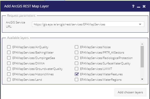
This requests tiles in the format: https://gis.epa.ie/arcgis/rest/services/EPAMapServices/WaterFeatures/MapServer/export?dpi=96&transparent=true&format=png32&layers=show%3A2&bbox=-870963.0119157883%2C6911089.850464204%2C-814514.2665272616%2C6945448.294678345&bboxSR=102100&imageSR=102100&size=1477%2C899&f=image
However many sublayers have their visibility set to false by default and so cannot be displayed, e.g. https://gis.epa.ie/arcgis/rest/services/EPAMapServices/WaterFeatures/MapServer/4 has "Default Visibility: false".
These can be turned on using the following querystring: layers=show:1,2,3
For example the following shows the same tile with all layers turned on:
https://gis.epa.ie/arcgis/rest/services/EPAMapServices/WaterFeatures/MapServer/export?dpi=96&transparent=true&format=png32&layers=show:1,2,3,4,5,6,7&bbox=-870963.0119157883%2C6911089.850464204%2C-814514.2665272616%2C6945448.294678345&bboxSR=102100&imageSR=102100&size=1477%2C899&f=image
I'm unsure if there is a ``layers=show:all` option available that could be used. Otherwise individual layers would need to be displayed, or allow some way of turning all layers on by default.
When accessing a layer such as https://gis.epa.ie/arcgis/rest/services/EPAMapServices/WaterFeatures/MapServer/ using the
BasiGX.view.form.AddArcGISRestform, all sublayers are grouped together:This requests tiles in the format: https://gis.epa.ie/arcgis/rest/services/EPAMapServices/WaterFeatures/MapServer/export?dpi=96&transparent=true&format=png32&layers=show%3A2&bbox=-870963.0119157883%2C6911089.850464204%2C-814514.2665272616%2C6945448.294678345&bboxSR=102100&imageSR=102100&size=1477%2C899&f=image
However many sublayers have their visibility set to false by default and so cannot be displayed, e.g. https://gis.epa.ie/arcgis/rest/services/EPAMapServices/WaterFeatures/MapServer/4 has "Default Visibility: false".
These can be turned on using the following querystring:
layers=show:1,2,3For example the following shows the same tile with all layers turned on:
https://gis.epa.ie/arcgis/rest/services/EPAMapServices/WaterFeatures/MapServer/export?dpi=96&transparent=true&format=png32&layers=show:1,2,3,4,5,6,7&bbox=-870963.0119157883%2C6911089.850464204%2C-814514.2665272616%2C6945448.294678345&bboxSR=102100&imageSR=102100&size=1477%2C899&f=image
I'm unsure if there is a ``layers=show:all` option available that could be used. Otherwise individual layers would need to be displayed, or allow some way of turning all layers on by default.