Hi,
I've encountered two situations where I was unable to create Voronoi grids from a polygon shapefile. Since I suspect this is a rather common approach for delineating a model domain, I thought I should share my experiences and how I managed to work around the issues, in case anyone is experiencing the same problems.
Issue 1:
Polygon shapefiles created using ArcGIS will have the starting AND closing vertice at the same location. e.g.
polygon_shp = np.array([
    [ 1000.0, 1000.0], #First and last points are located at the same position
    [ 1000.0, 2000.0],
    [ 2000.0, 2000.0],
    [ 2000.0, 1000.0],
    [ 1000.0, 1000.0] #First and last points are located at the same position
])
Although creating a triangular mesh using this array works fine, instantiating a Voronoi grid based on that triangular mesh will throw an error, e.g.
voronoi_grid = VoronoiGrid(tri.verts) will trigger:
---------------------------------------------------------------------------
AttributeError                            Traceback (most recent call last)
shapely\speedups\_speedups.pyx in shapely.speedups._speedups.geos_linearring_from_py()

AttributeError: 'list' object has no attribute '__array_interface__'

During handling of the above exception, another exception occurred:

ValueError                                Traceback (most recent call last)
<ipython-input-15-2cc6e6ba8ade> in <module>
----> 1 voronoi_grid = VoronoiGrid(tri.verts)
      2 fig = plt.figure(figsize=(10,10))
      3 ax = plt.subplot(1, 1, 1, aspect='equal')
      4 voronoi_grid.plot(ax=ax, facecolor='none')

c:\users\nat12nho\appdata\local\programs\python\python38\lib\site-packages\flopy\utils\voronoi.py in __init__(self, points, **kwargs)
    158
    159     def __init__(self, points, **kwargs):
--> 160         verts, iverts = get_voronoi_grid(points, **kwargs)
    161         self.points = points
    162         self.verts = verts

c:\users\nat12nho\appdata\local\programs\python\python38\lib\site-packages\flopy\utils\voronoi.py in get_voronoi_grid(points, **kwargs)
    116             poly = sort_vertices(poly)
    117             xc, yc = points[n]
--> 118             if not point_in_cell((xc, yc), poly):
    119                 new_vor_vertices.append((xc, yc))
    120                 iv = len(new_vor_vertices) - 1

c:\users\nat12nho\appdata\local\programs\python\python38\lib\site-packages\flopy\utils\voronoi.py in point_in_cell(point, vertices)
     33
     34     p = Point(point)
---> 35     poly = Polygon(vertices)
     36     if p.intersects(poly):
     37         return True

c:\users\nat12nho\appdata\local\programs\python\python38\lib\site-packages\shapely\geometry\polygon.py in __init__(self, shell, holes)
    241
    242         if shell is not None:
--> 243             ret = geos_polygon_from_py(shell, holes)
    244             if ret is not None:
    245                 self._geom, self._ndim = ret

c:\users\nat12nho\appdata\local\programs\python\python38\lib\site-packages\shapely\geometry\polygon.py in geos_polygon_from_py(shell, holes)
    507
    508     if shell is not None:
--> 509         ret = geos_linearring_from_py(shell)
    510         if ret is None:
    511             return None

shapely\speedups\_speedups.pyx in shapely.speedups._speedups.geos_linearring_from_py()

ValueError: A LinearRing must have at least 3 coordinate tuples
However, omitting either the firs or last point of the polygon will work:
will_cause_error_shp = np.array([
    [ 1000.0, 1000.0], #First and last points are located at the same position
    [ 1000.0, 2000.0],
    [ 2000.0, 2000.0],
    [ 2000.0, 1000.0],
    [ 1000.0, 1000.0] #First and last points are located at the same position
])

will_work_shp = np.array([
    [ 1000.0, 1000.0],
    [ 1000.0, 2000.0],
    [ 2000.0, 2000.0],
    [ 2000.0, 1000.0],
])
The second problem seem to arise from any situation where decimals are present. For example:
will_work_shp = np.array([
[ 1000.1, 1000.0], #The decimal will cause the creation of a malformed voronoi grid
[ 1000.0, 2000.0],
[ 2000.0, 2000.0],
[ 2000.0, 1000.0],
])
See img for example of the second problem:
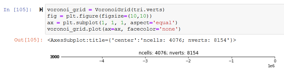
Since a polygon shapefile from a real-world location is likely to contain decimals, the work-around is to round off the points to the nearest integer.
I hope these suggestions help anyone with similar problems.


Hi,
I've encountered two situations where I was unable to create Voronoi grids from a polygon shapefile. Since I suspect this is a rather common approach for delineating a model domain, I thought I should share my experiences and how I managed to work around the issues, in case anyone is experiencing the same problems.
Issue 1:
Polygon shapefiles created using ArcGIS will have the starting AND closing vertice at the same location. e.g.
Although creating a triangular mesh using this array works fine, instantiating a Voronoi grid based on that triangular mesh will throw an error, e.g.
voronoi_grid = VoronoiGrid(tri.verts)will trigger:However, omitting either the firs or last point of the polygon will work:
The second problem seem to arise from any situation where decimals are present. For example:
will_work_shp = np.array([
[ 1000.1, 1000.0], #The decimal will cause the creation of a malformed voronoi grid
[ 1000.0, 2000.0],
[ 2000.0, 2000.0],
[ 2000.0, 1000.0],
])
See img for example of the second problem:
Since a polygon shapefile from a real-world location is likely to contain decimals, the work-around is to round off the points to the nearest integer.
I hope these suggestions help anyone with similar problems.